

La prima settimana di marzo e’ solitamente quella con la maggior quantita’ di neve al suolo, almeno nella parte meridionale della Finlandia, perche’ poi da meta’ mese inizia il lento ma inesorabile scioglimento. Le foto sono state scattate nei luminosi giorni di sole che fine-febbraio e inizio-marzo ci hanno regalato.
Una curiosità: anche il sole inizia in questo periodo ad essere efficace per riscaldare l’aria e creare escursione temica tra il giorno e la notte: se di notte abbiamo -10 C, di giorno possiamo andare vicino allo zero o superarlo; mentre a gennaio non c’è praticamente escursione termica e possiamo avere -10 di notte come di giorno. Effetto primavera!
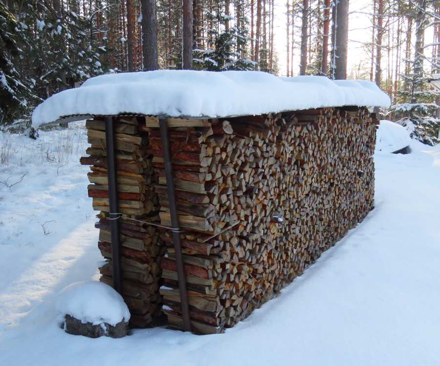


Snow in March. Statistically, in the first week of March we have the maximum amount of snow of all winter on the ground, at least here in south Finland; after this week usually snow will slowly start melting away. My photos were taken just on a bright sunny day, as we had many this year in the first week of March.
A curiosity: in this time of year the sun begins to warm up the air considerably and you can feel the temperature range between day and night. If we have -10 C at night time, we can have 0 C or more in the daytime now; whereas in January we had the same temperatures day and night. Spring effect!
****
Linked to: MakroTex Challenge. WATW.

bellissima la neve con la luce di marzo ciaoooo
"Mi piace"Piace a 1 persona
Ma grazie! Ciaoooo
"Mi piace"Piace a 1 persona
Quanto mi piace la legna ! 🖤 La neve bianca e gli abeti verdi sono una gioia 🌲
Qui dove abito io piove oggi. Gli uomini di neve gridano aiutoooo…. 😀⛄️
"Mi piace"Piace a 1 persona
Love your pine pictures!
"Mi piace"Piace a 1 persona
Snow sparkles so beautifully in your photos!
"Mi piace"Piace a 1 persona
Paljon vielä lunta.
"Mi piace"Piace a 1 persona
What a lovely sunshine comes through the pine! Maybe there is Tinker Bell. 😀
"Mi piace"Piace a 1 persona
A lot of sparkling snow. Beautiful!
"Mi piace"Piace a 1 persona
Hyvin tehty puupino! Ja lunta, lunta – tämä talvi on ollut luminen.
"Mi piace"Piace a 1 persona
Puupino is my husband’s work…thanks! Ja lumi on aina hieno-it makes the landscape shine!
"Mi piace""Mi piace"
Yes…you can never know…in the Finnish forests…! 😉
"Mi piace""Mi piace"
Yes, it was just the starting of March… Thanks for your visit!
"Mi piace""Mi piace"
Thank you, Riitta! Have a lovely week!
"Mi piace""Mi piace"
Thank you. It is a lovely landscape!
"Mi piace""Mi piace"
Poveri uomini di neve…li capisco! Grazie della visita, Rita!
"Mi piace""Mi piace"
Thank you. The start of March was snowy and bright. I really enjoyed it!
Thanks for your visit.
"Mi piace""Mi piace"
😍😍😍👏
"Mi piace"Piace a 1 persona
😍😍😍
"Mi piace""Mi piace"
Thank you and welcome to my blog!
"Mi piace""Mi piace"
It all just looks so pretty
Mollyx
"Mi piace"Piace a 1 persona
I guess the snow has to have a last hurrah, doesn’t it! Stay warm! Happy weekend!
"Mi piace"Piace a 1 persona
Thank you, Kelleyn. You said it right: let’s enjoy the white immaculate landscape as long as we have it! Happy weekend!
"Mi piace""Mi piace"
Thank you so much, Molly. Your photos are very effective too. Have a sunny weekend!
"Mi piace""Mi piace"
Belle foto invernali !
Le temperature sono molto simili alle nostre, almeno quest’anno…
"Mi piace"Piace a 1 persona
Che bello…non vedo l’ora di venire a fare un giro dalle tue parti! Stavolta ho in programma Sankt Vigil in Enneberg! 😉
"Mi piace""Mi piace"
Beautiful!💖
Chicago had that much snow in January.
We have Spring weather now.🌹
"Mi piace"Piace a 1 persona
Thank you so much. I’d love to see Chicago some day… Thanks for stopping by!
"Mi piace""Mi piace"
You’re welcome! 😊
"Mi piace"Piace a 1 persona
Lovely light!
"Mi piace"Piace a 1 persona
Thank you. It was a lovely day…
"Mi piace""Mi piace"